What river runs through rome — your simple guide to the Tiber today
You’re asking what river runs through Rome because maps, photos, and tours keep showing a broad ribbon of water next to famous sights. The short answer: the Tiber River (Italian: Tevere) flows through Rome from north to south, then reaches the Tyrrhenian Sea near Ostia. It’s about 405 km / 252 miles long, rising on Monte Fumaiolo in the Apennines and emptying near the coast west of the city.
Meet the Tiber: where it is and why it matters
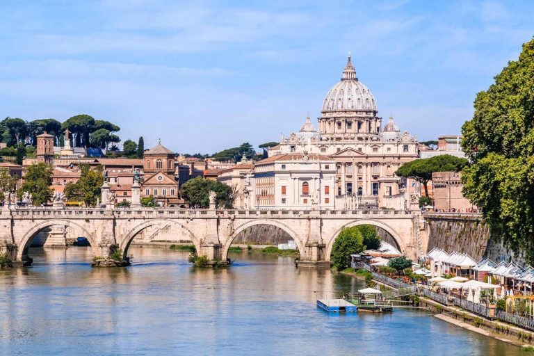
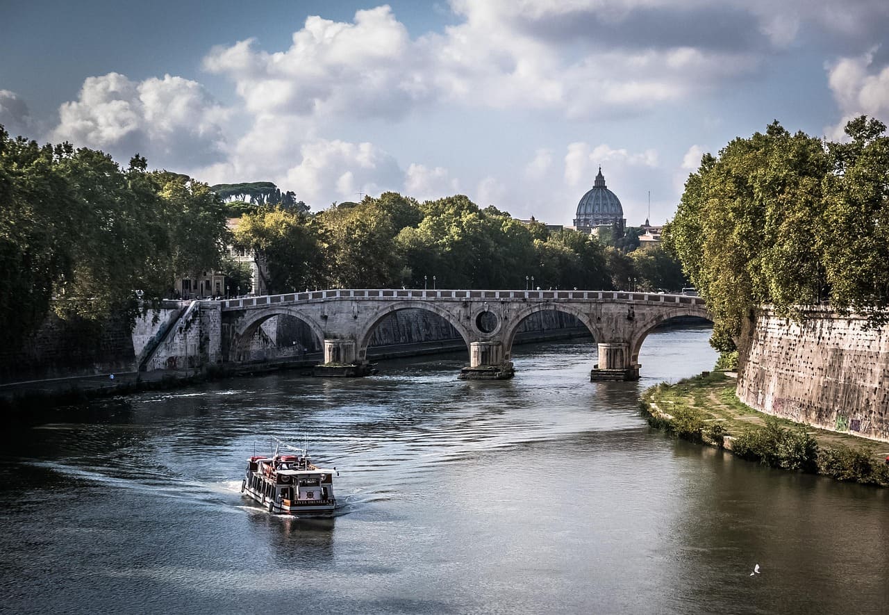
Stand on the embankment near Castel Sant’Angelo and you’ll see the Tiber curve under stone arches and toward St. Peter’s dome. The river splits around Isola Tiberina, a small island that anchors two of Rome’s oldest bridges. For 2,000+ years the Tiber has shaped trade, defense, religion, and daily life in the city. Its banks, called lungoteveri, were walled in the late 1800s to control floods and create today’s broad riverside roads.
Quick orientation (so you can picture it)
- Upstream (north): neighborhoods like Prati and Flaminio.
- Center: the river glides past Ponte Sant’Angelo, Ponte Sisto, Trastevere, and Piazza Navona (a short walk away).
- Downstream (south): it skirts Testaccio and the ancient river port area, then heads toward Ostia Antica and the sea.
7 powerful facts about the Tiber (that actually help you visit)
1) The Tiber is Rome’s original “highway”
In ancient Rome, barges carried grain, marble, and goods right into the city. The river’s ford and island made it a natural crossing, which is one reason Rome rose here and not 20 km away. The Carthaginian and later imperial trade routes relied on this steady waterway—and you still feel that logic when you cross the bridges today.
2) The river created (and solved) a big city problem
Rome sits on low ground and seven hills; heavy rains used to send the Tiber over its banks. The flood-control embankments you see now were built in the late 19th century, taming seasonal floods and reshaping the waterfront into today’s broad terraces. That engineering move protected residents and monuments—and it’s why streets like Lungotevere are straight and elevated.
3) A hidden mega-drain still meets the Tiber
Beneath your feet runs the Cloaca Maxima, one of the world’s oldest large sewers, begun in the regal era to drain marshes between the hills and channel water to the Tiber. It’s the backbone of Rome’s early urban planning and proof that the city has wrestled with water for millennia.
4) Vatican City is next door—but not “on” the river
Vatican City sits just west of the Tiber. You’ll cross a bridge from central Rome into the Vatican area, but the micro-state itself doesn’t straddle the river. That’s helpful when planning your walking route between the Vatican Museums and central sights.
5) Swimming is not allowed (yet), but there’s buzz
Right now, swimming is prohibited in the Tiber. The mayor has announced a plan to make parts of the river swimmable within five years, inspired by Paris’s Seine clean-up, but experts are cautious about the timeline. Treat it as a long-term project rather than a guarantee for your next trip.
Extra reading: Reuters – plan for a swimmable Tiber.
6) Boats? Yes—think views, not transport
You’ll find seasonal boat cruises, kayaking and rowing clubs, and occasional festival rafts. They’re great for views of domes and bridges, but the river is not an everyday commuter line like the Thames or Seine. Focus on sightseeing value: golden evening light, reflections under arches, and peaceful stretches south of the island.
7) The Tiber shapes your sightseeing more than you think
The river is a navigation tool. Heading from the Roman Forum to Trastevere? Aim for the water then cross. Moving between the Pantheon area and Castel Sant’Angelo? Follow the curve northward. Many top photo spots—sunset from Ponte Umberto with St. Peter’s in the background, or dawn mist at Ponte Sisto—exist because of the Tiber’s gentle bends.
Walking the river, step by step
Classic route for first-timers (easy, flat, scenic)
Start near Ponte Umberto, look toward St. Peter’s dome, then wander to Ponte Sant’Angelo for statues and castle views. Continue to Ponte Sisto to watch street artists and musicians drift into the frame. At Isola Tiberina, linger for island photos, then cross to Trastevere for a gelato. This loop keeps you close to the water without long detours.
Where to catch your breath
- Under the embankments: ramps lead down to shaded paths used by joggers and cyclists.
- On the bridges: most have central viewpoints; be mindful of bikes and vendors.
- By the island: quiet nooks on the Trastevere side give you calm frames of the current.
Safety and comfort tips
The lower paths can be isolated at off-hours. Visit during daylight or early evening, keep your valuables close, and prefer the upper sidewalks when it’s late or very quiet. After heavy rain, the lower level may be damp or muddy.
Why the Tiber made Rome possible (ancient story, short and sweet)
Think of the Tiber as Rome’s lifeline. It offered fresh water, fertile floodplains, a defensible crossing at Isola Tiberina, and access to the sea via Ostia. The early Republic could ship supplies upriver; the Empire could move marble and grain. Even sacred stories—from Romulus and Remus to Augustan propaganda—lean on the river’s symbolism. Without the Tiber, the city’s growth into the capital of Europe’s Roman Empire would have been far less likely.
People also ask (and you might, too)
Is the Tiber River clean to swim in?
No. Swimming is currently banned for safety and health reasons. The city is exploring long-term clean-up targets, but timelines are uncertain; plan for dry feet for now.
Can you take a boat ride on the Tiber?
Yes—mostly leisure cruises or paddles. They run seasonally and depend on river levels. Book them for views, not for point-to-point transport.
Does the river go through Vatican City?
No. Vatican City lies just beyond the west bank, reached by bridges from central Rome.
Where does the Tiber start and end?
It rises on Monte Fumaiolo in the Apennines and flows into the Tyrrhenian Sea near Ostia, after crossing central Italy.
Story moment: a five-minute scene you can copy
It’s golden hour. You’re standing on Ponte Sisto with the silhouette of Castel Sant’Angelo downriver. You wait two minutes, then a rower slides through the light, leaving a clean ripple across the green water. Snap. That one frame sums up a modern truth: the Tiber is calmer than the streets above, and it gives you a classic Rome photo without a crowd.
Another night, wander to Ponte Umberto. Line up St. Peter’s dome beyond the river curve. The glow from the embankment lamps turns the Tiber into a ribbon of bronze. No need to rush; the reflections get better as the sky deepens.
How the river connects your favorite sights
- Pantheon → Tiber: a 10–12 minute stroll west puts you on the water; turn right for Castel Sant’Angelo, left for Trastevere.
- Colosseum/Forum → Tiber: aim for Teatro di Marcello, then descend to Isola Tiberina for a midpoint pause.
- Vatican Museums → center: cross at Ponte Sant’Angelo; the castle courtyard doubles as a photogenic rest stop.
(Exact times vary with pace, but the river is a reliable compass when the alleys get twisty.)
Best months and times for the Tiber
- Spring & early autumn: softer light, mild temperatures, and leafy banks—top for photos.
- High summer: strong sun and more visitors; plan early morning or late evening for cooler walks.
- After rain: water can turn fast and murky; check the lower paths before descending.
- At night: stick to well-lit upper sidewalks and the busier bridges.
Mini-guide to bridges you’ll actually remember
- Ponte Sant’Angelo: Bernini’s angels, a straight sightline to the castle.
- Ponte Sisto: a social sunset stage over the current.
- Ponte Fabricio & Ponte Cestio: the twin links at Isola Tiberina, oldest in continual use, anchoring the island to both banks.
Walk them, pause halfway, and let the city slide by on the water.
The Tiber in numbers (so you can compare)
- Length: about 405 km / 252 miles.
- Direction through Rome: roughly north–south, curving westward toward the sea.
- Mouth: near Ostia, into the Tyrrhenian.
- Iconic island: Isola Tiberina, natural stone “stepping-stone” mid-stream.
Quick planning tips (save these for your trip)
- Use the river as a route: when lost, head for the Tiber and re-orient from a bridge.
- Plan a “river hour”: one golden-hour stroll gives you top-tier photos with little effort.
- Mind the levels: lower paths can be closed after storms.
- Don’t swim: the rules are clear; enjoy views and boats instead.
FAQ
What river runs through Rome?
The Tiber River (Tevere) flows through Rome’s center and out to the sea near Ostia.
How close is the river to major sights?
Very close: a short walk from the Pantheon, Piazza Navona, or Trastevere puts you on the bank or at a bridge in minutes.
Is the Tiber dangerous?
For visitors, the usual precautions apply: watch your footing on ramps and avoid isolated lower paths late at night or after heavy rain.
Can I photograph the river from Vatican City?
Yes—stand on the bridges near the Vatican side for classic dome-and-river shots, but remember the micro-state sits beside (not over) the Tiber.
Wrap-up
What river runs through Rome? The Tiber River—a 405 km waterway that rises in the Apennines, curves past Rome’s historic core (by Isola Tiberina, Castel Sant’Angelo, and more), and reaches the Tyrrhenian Sea near Ostia. Today you can’t swim in it, but you can walk, photograph, and cruise it—using the river itself as your easiest guide to the city